Tuesday, May 26, 2009

Annapolis and Baltimore Here We Come!


May 20, 2009, Annapolis, Maryland


Charlie and I and our friends Les and Judy, from the boat Voyager II, toured The U.S.Naval Academy. It was a fabulous day!


When our tour of the Naval Academy ended, we were able to watch a ceremony known as the Noon Meal Formation/Brigade Change of Command Ceremony (above). The building in the center background is Memorial Hall. In this hall, we saw numerous plaques on it's walls honoring all men and women in military services who having died in the line of duty. The wings on either side of Memorial Hall are the dormitory halls of Bancroft Hall; the largest dormitory in the U.S. with over 4,000 midshipmen living there.


There were also many special events and many visitors on campus while we where there because it was graduation week. More of our Naval Academy day further down in this blog.


Before we give an overview of our visits to Annapolis and Baltimore, we'll give you our current location.


Today is Friday, May 29 and the crew of Freedom's Turn just tied her up in a slip for two nights at Utsch's Marina in Cape May New Jersey. To back track, last night she stayed along the main dock at Delaware City Marina, Delaware. The night before that, she spent one night in Chesapeake City, Maryland after leaving Baltimore that morning, May 27.


To get from Baltimore, Maryland to Cape May, New Jersey, Freedom's Turn traveled on the Chesapeake and Delaware Canal. (the C&D Canal is a man made shortcut dating back to the early 1800's that connects the Chesapeake Bay to the Delaware Bay and is about 15 miles long)

When we leave Cape May, we'll cruise on the outside of New Jersey in the Atlantic Ocean for one day to Atlantic City, then cut into the New Jersey ICW to Sandy Hook. From there we will take a loop around Staten Island, New York then head up the Hudson River to Albany!


Freedom's Turn is traveling with two Great Loop boat buddies these days; Queen Ann's Revenge and a new friend, Izzy R, who Linda and Charlie met while in Baltimore.


Annapolis, here we come


We entered the historic port of Annapolis on May 20. We read that Annapolis is known as a museum without walls. It is a modern day city in an antique setting; dating back to the American Colonial period in the early 1700s. One of my pamphlets stated that Annapolis boasts of more 18th century buildings continuously used than in any other city in the U.S. Pictures from the colonial days show the docks and city much like it is today. The roads of the city come down to the waterfront like spokes on a wheel with the state capital in the center of the wheel. There are no skyscrapers or big condo developments here. The highest buildings that we can remember seeing as we entered the harbor were the Naval Academy's Chapel dome, the State House dome, and the steeple of St. Anne's Episcopal Church.


In 1694, Anne Arundel Town was made into a capital city and rechristened Annapolis in honor of the heir to the British Throne, Princess Anne.


Tobacco farming thrived here and farmers began to rely on the work of slaves in the 18th century. Annapolis was a main stop for the slave trade boats from Africa. There is a bronze sculpture near the city docks in Annapolis of Pulitzer prize winner Alex Haley reading to a group of children out his book "Roots." The sculpture commemorates the arrival of Haley's ancestor, Kunta Kinte to Annapolis aboard the slave ship Lord Ligonier.


Below, we are just entering the harbor. There are sailboats everywhere, all eyes looking up at a practice of the the Navy's Blue Angels. You can see the dome of the Naval Academy's Chapel in the distance.

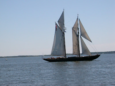


We read that Annapolis is the sailing capital of the world. A beautiful sailing vessel entering the Annapolis harbor.


Below is the Annapolis Yacht Club finishing up their Wednesday evening regatta. They were on the other side of a bridge from our slip.


Above, our slip at the Annapolis Yacht club. It is a private club but we could stay there with a reciprocal agreement between the yacht club and with an organization we belong to called the Marine Trawlers Owners Asocition. (M.T.O.A) We have used this privilege three times so far on the trip, saving money and getting great marinas to stay at. I took this picture of Charlie as I walked back from the bridge. He is partaking in his own personal happy hour complete with a cigar.


Behind us at the dock is the boat Voyager II with our friends Les and Judy.


Annapolis is Maryland's state capital. Here is front side of the State House, our nation's oldest capital building in continuous legislative use.


As stated on the plaque, Annapolis was the Nation's capital city briefly for nine months from 1783 to 1784.


This dome (a side view of the state house here) is a one of three landmarks we saw entering the harbor.


Right after we got settled into our slip, we changed our boat shoes for our walking shoes and took a lovely walk to the nearby historical part of the town.


Above, everywhere we looked, there were navy midshipmen walking; dressed in their whitest of whites. The building in the background is very famous as it is the Maryland Inn where the restaurant "Treaty of Paris" is still in operation since the early 1800's. John Adams, John Jay, and Benjamin Franklin came to eat here just after returning from France where they signed the Treaty of Paris, ending the War of 1812.


We had hoped to eat in the restaurant but it was not open during the week. Luckily, we found a door open and went in to sneak a peak. It was an elegant American Colonial dining room done in mostly golds.


When in the Bahamas with no TV service, Charlie and I watched a DVD set of the HBO miniseries "John Adams" which got us primed for this area of the country. We would heartily recommend watching the miniseries.


Speaking of the midshipmen walking around, here is a photo of me and the guys......


It was a spur of the moment and I took the opportunity to pose with these first year midshipmen.


This gentleman is a retired Navy man and he was our wonderful tour guide. Here he shows us with great pride, the footballs depicting all the Navy over Army victorieson a display in Ricketts Hall, the NCAA Athletic Building on campus here. The football stadium is nearby and seats 40,000. Their mascot is a goat!


By the way, this great two hour tour costs us only $8.00 apiece. We had to show a photo ID.


In 1845, the War Department acquired Fort Severn and adjoining land to house the newly established Naval College, now the U.S. Naval Academy. The campus has 338 acres and borders the city of Annapolis and the Severn River.


Getting accepted into the Naval Academy is very tough but once accepted, it means getting a four year scholarship paying for room and board and tuition plus a monthly allowance of $900 to use for books and other things like uniforms. There is an additional monthly allowance for their funny money of $100 for the 1st years,$200 for the second years, $300 for the third years and $400 for the fourth years. Our tour guide informed us that the enrollment each year averages between 4,000 and 4,500 with about 20% females to 80 % males in the first year and by graduation, 10% of the females and 20 % of the males that began, have dropped out. The females have a better sucess rate!


The Academy offers twenty-two academic majors, mostly technological degrees.


It was great fun to learn about the rituals and rules of the academy. For instance, a first year midshipmen is never supposed to be seen on campus sitting down; they always have to stand or be walking!


Beautiful Memorial Hall. We could not go up these steps because there was a ceremony pertaining to graduation going on but we could look at the top of the stairs and just make out the words of a famous Navy slogan: "Don't give up the ship."


Above, the inside of the Interdenominational U.S. Naval Academy Chapel with an original Tiffany window. It was a magnificent building. The chapel houses the crypt and sarcophagus of Revolutionary hero, John Paul Jones. He is credited with being the leader of the first Continental Navy for the American Colonies even though he was born in Scotland.


The outside of the chapel.


After our tour the four of us decided to stay on campus and join the several other folks to get a first rate view of the Navy's premier Blue Angels pilots demonstration; a special event for graduation week.


We were awed by their performance which lasted a little over an hour. There were six jets in all doing unbelievable swoops and dives and even upside down. (see below)


And the sound they make is a show in itself.


We hit it just right to be on campus this day! We could have spent more time in this wonderful city but the next day we had reservations in Baltimore so we said good-bye to Annapolis; hoping to come back here again someday in our future.

Welcome to Baltimore, founded in 1729


Here is our spot on the city dock finger pier in Baltimore's Inner Harbor. We had a delightful six day stay. As mentioned in the previous blog, the price was one half of a normal per ft. charge of other marinas in the area and we were right in the middle of the action! In a panoramic view, we were surrounded by sights and lights.


Then there were the sounds of this big city which engulfed us and somehow made us feel like we were a part of it all; like the welcoming sounds of numerous church bells and the chimes coming from an obscure city clock, with chimes heard every hour.


And what really made us stop and listen was the city playing patriotic songs in the Inner Harbor during the mornings.


We took this photo above from our boat. Pictured above is the U.S.S. Constellation, the only remaining ship from the Civil War still floating in the water. She is also the last all sail ship the U.S navy built before steam replaced wind as the standard source of power. The ship was used to help fight the transatlantic slave trade.


There are three other ships as part of the Baltimore Maritime Museum in the harbor as well: a WW II submarine, the USS Torsk, that sank the last two Japanese warships in the war of the Pacific, a Coast Guard ship named Taney,the last suriving vessel from the attack on Pearl Harbor in 1941, and a lighthouse ship, the "Chesapeake" used to provide a safe passage to incoming ships into Baltimore. All four boats are open to the public. We heard the live cannon firings of the USS Constellation in the Inner Harbor.


Charlie and I have gotten so much information when visiting several cities on our trip by taking a tour. The Visitors Center was located right next to our dock so we signed up for a Baltimore trolley tour with them. Our tour guide was excellent. For entertainment, he put on a special hat depicting different periods of history as we went along.


We learned that Baltimore is a city of "firsts" for the U.S. First factories for the following: umbrellas, tin cans, straw hats, gas lights, and the making of chrome. It is also the city of the first regularily published newspaper, the first senior citizen apartments, first Catholic Basilica, first Unitarian church, first Evangelical Lutheran church, the first YMCA, first Church of England in the U.S. which is dated from 1692.


While on the trolley tour, we saw several neighborhoods within walking distance so later in the week we explored more by foot. Among the many attractions on the tour were Federal Hill; quaint streets with open markets and little street cafes, Fell's point nautical heritage, Little Italy restaurants, Edgar Allen Poe's home and burial place, and the historical Fort McHenry.

Later Charlie and I went to the Cross St. Market in Federal Hill and strolled down the open booths filled with fresh produce, flowers and seafood. Charlie went on his own to buy an ice cream cone and on a later trip, he purchased cigars in a cigar shop, and lingered there to join other smokers in their smoking room.


I went to a fantastic used book store and stocked up on more reading material and toured the Visionary Art Museum which is a museum of self taught, contemporary artists.


On another day, Charlie walked to the Sports Legends Museum at Camden Yards and the Babe Ruth Museum.


Fort McHenry was a highlight for us to see. The flag flying at the fort shown below is a replica of what was later known as the Star Spangled Banner flag. It flew here during the War of 1812. Americans turned back the attack of the great and powerful Britian here. Fort McHenry and on the land side, east of Fells Point, is where our Nation was saved.


Our tour guide informed us that this flag is only flown on special days of the year. Because we were here on Memorial Day weekend, we were lucky to see it, our guide said. The flag is flying in the exact location where Francis Scott Key saw it on the night he wrote our national anthem.


We first saw the flag and the fort as we entered the harbor. It was a thrill for us to see the spectacular view from our own boat; first the red and white blue bouy marking the location of the British ship holding Francis ScottKey prisoner, and then following the direct line across the harbor to the Fort to see flying the exact replica of our county's Star Spangled Banner. You can see the bouy in the top photo.


This experience was probably in the top ten of all sights we have seen on the trip to date. Both the flag and the buoy are only put out by the city on very special days and weekends and we were there to see them both!


Above, Fort McHenry and an exact replica of the Star Spangled Banner flag.


The Star Spangled banner, a giant 30' by 42' flag, was sewn in this house by Mary Young Pickersgill. The orginal flag is in the Smithsonian in Washington, D.C. You can see a sign in the background of the flag in it's actual size.


Baltimore and Fellspoint served as a hotpoint of underground railroad activity. Charlie and I visited the Civil War Museum which was known orginally as the President Street Railroad Station; one of three railroad stations in Baltimore during the period just before and during the Civil War. This train station was a hub for providing a means to freedom for escaping slaves.


Through a series of photos inside the museum, we also learned that outside the doors of the President Street Station, the first death of the Civil War occurred. On April 19, 1861, a volunteer militia from Massachusetts arrived here on a train on their way to Washington D.C. and was attacked by a mob of angry southern sympathizers. One man was mortaly wounded and his picture is up above. He is the first death of the Civil War. As I write this, I cannot find his name in my notes. I remember he was only 17 when he died. History tells us his picture was put in the northern papers after the attack and ignited a rage among the northerners.


Fort Sumter near Charleston was the first battle of the Civil War but there were no deaths there.
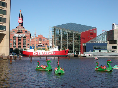
From our boat, we took this photo of the Chesapeake lightship and the submarine USS Torsk in the background. We spent an afternoon touring the National Aquarium which is the modern looking cube you can see in the background. There were water taxis taking people to and from places on the harbor and for the children, these fun dinosour paddleboats came out everyday.


Once a shipping harbor, Baltimore's Inner Harbor is a now definitly a recreational harbor welcoming visitors of all ages. This 'pirate" ship was a frequent sight from our spot on the dock.


On our last day here, we visited the National Aquarium. It was very well done with special exhibits including an awesome jellyfish exhibit.


Above, this is my friend Ann from the boat Queen Ann's Revenge, which is another Great Loop boat staying here at the city docks the same time we were. In the background is the hill that gave the neighborhood of Federal Hill it's name. Before the Emancipation Proclamation of 1863, Federal Hill once hid escaping slaves in tunnels made inside the hill. Before that time, in 1788, 4,000 patriots celebrating Maryland's ratification of the U.S. Constitution, climbed to the top of the hill for a picnic and fireworks. Charlie walked over there and said it was beautiful and peaceful up there.


Seeing some of our country's early history from the water has been so wonderful. But we'd have to say that it is making friends like Ann and her husband Hank and many other friends we have made since we left home nearly ten months ago, that puts this trip over the top.


To all our friends out there on the Loop and our friends back home;


we appreciate your friendship very much.


Sincerely,


Linda and Charlie


Friday, May 22, 2009

Cruising the Chesapeake Bay, Part 2

Explanation of map found in the blog text below. Click on map for enlargement. Freedom's Turn will continue north to Chesapeake City then onto Cape May, NJ by May 29.
Solomons Island "Screwpile Lighthouse" displayat the Calvert Maritime Museum. The stilts are screwed into the muddy soil in the Chesapeake Bay which enables the lighthouses to be placed off shore.


Since the last blog, Freedom's Turn has taken us to the following ports on the western side of the Chesapeake Bay for a distance of 265 statue miles.


Portsmouth, VA May 11-12: Ocean Marine Yacht Center

Deltaville, VA May 13-14: Dozier's Regatta Point Marina

Solomons Island, MD May 15-18: Zahnizer Marina

Annapolis, MD May 19-20: Annapolis Yacht Club

Baltimore, MD May 21 to the present day of May 25- Baltimore City Docks

Well, it has been almost two weeks since we last published the Dismal Swamp blog and it's time to do another one because our friend Louis called and wondered if we were stuck in the swamp or have continued on!

Today marks our sixth day of a long Memorial Day weekend at the Baltimore
City docks in the Inner Harbor of Baltimore, Maryland. We are having a fabulous time.


Hank and Ann and their boat Queen Ann's Revenge is here also and we have enjoyed being with them.

The city docks are finger piers off of the wall and are offered to transient boaters on a first come first serve basis. The harbormaster's office and facilities are two blocks away, with just a small building at the dock for an attendant that greeted us and helped us tie up upon our arrival. The price to stay here is great, though, at $1.25 ft and $4 for electricity per night compared to the three marinas in the harbor at $3 ft and $12-15 per night for the electricity.

So we use our head and shower on-board. We are in front of a great visitor's center and we look out our windows and see a beautiful waterfront setting with museums, ships and skyscrapers. More about Baltimore in the next blog.

Our friends Jim and Sandy on Footloose went to another marina in Baltimore for a long term stay so they can leave their boat and travel to Texas to see their family. We met up with them here in Baltimore the other day for a stroll and an ice cream cone and said farewell, we'll see you again somewhere we hope!


Portsmouth, VA

We left the Dismal Swamp on a damp and cool day and traveled 35 miles to Ocean Marine Yacht Center Marina in Portsmouth. Charlie wanted to get fuel and have a pump out so we radioed ahead and the harbor master greeted us at the fuel dock. Freedom's Turn took 158.70 gallons at $1.81; the lowest price we have found, to date on the trip.
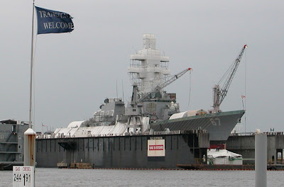
I got off the boat to stretch my legs and look around for a few minutes. That is when I saw a Navy ship with a number 67 on it across the harbor. To my surprise, Harbormaster John told me the ship was the Naval Destroyer USS Cole; the same ship bombed in a suicide attack in October of 2000 while it was harbored in the Yemeni port of Aden. Seventeen U.S. sailors were killed on that ship at that attack. These days the ship is getting fitted for a new bow shape for better displacement.


The USS Cole

We had planned to stay the next day so we got into our slip, tied the lines, put fenders in place, and hooked up our two, 30 amp electrical lines into our 50 amp splitter (we use this splitter almost every time) and plugged into the 50 amp shore power at our slip. For a 48 hour turn around, we did not hook up the water hose so we made it easy by just using the water from our tanks. Charlie checked the engine and it's oil while I did the laundry and some blog writing. A simple dinner eaten on-board on a chilly but cozy night and off to bed early.


The next day it was sunny and warmer. Jim and Sandy from Footloose joined us for a ferry ride across the harbor to Norfolk, VA. There we toured the Hampton Roads Naval Museum and the USS Wisconsin and ate a great lunch in a restaurant that used to be a church.


One of many great displays inside the museum.


The USS Wisconsin below

Just before entering the museum, Sandy and I got our picture taken in front of a mermaid statue. The mermaid is Norfolk's cultural icon. We saw many of them that day around the town; all different sizes and and colors.


The mermaid below was exceptionally unique.


When the four of us began our tour of the USS Wisconsin, I realized a blog story here so I asked questions to the the Navy Veterans who were the tour guides and took down notes.


The USS Wisconsin is an 887 ft long Iowa-class battleship. She is in what the Navy calls "inactive reserve status" which means she can still be commissioned for duty if the need arises but for the time being, she stays in the harbor and visitors can come aboard and see limited areas.

Launched December 7, 1943, the USS Wisconsin has six battle stars for service, from WW II and the Korean War and after being modernized in the navy's 600 ship plan in 1986, received a navy 'Unit Commendation' for service in the Gulf War.

The ship is painted with Measure 13, the veteran told us. "What is measure 13?" I asked. His answer: "The paint scheme that the Wisconsin currently wears." He explained that all navy ships wear paint schemes called 'measures', designed to make it hard for the enemy to recognize the ships. Measure 13 is the navy's normal peacetime system of peace gray. This paint is the least visable under the widest range of light conditions. How cool is this I thought?


After more of my questions and Charlie raising his eyebrows at me like he does, the man lead me into the museum for more about the ship. He told me he had been assigned active duty on the USS Wisconsin during the Korean War.

This photo below is of a shell from a projectile from the ship. It came from one of nine barrels that can shoot up to 2 projectiles each for a total of 18 all at once. Each projectile can travel 2,700 ft a second or 27 miles in a minute; three times the speed of sound, my veteran friend told me. I regret I did not write down his name for he was very knowledgeable and kind enough to answer my questions.


Jim and Charlie standing along side of the USS Wisconsin. You can see some of the the barrels on top of the ship here.

When the four of us left, we thanked our veteran guide for his first hand information and more importantly, for his service to our country. We are proud of our military and do not tell them sometimes.

Freedom's Turn and Footloose left the following morning in route to Deltaville,VA to spend two nights at Regatta Point Marina. It is commonly known as Dozier's Marina, named after the family that manage the marina. The Dozier family publishes a series of important chart books for boaters (especially Great Looper Boats) known as The Waterway Guides. This marina has everything we needed in the line of basics plus a wine and cheese reception for us, a courtesy car to use to go into town and even a price cut for dockage for Great Loop boats.


Before we arrived in Deltaville, here is another Navy ship photo taken as we are leaving the Norfolk harbor. I saw many a Navy ship in movies growing up but never in person that I can remember. My family used to go to the drive-in movies during the summer months and after the cartoons, we would watch WW II movies sometimes like"South Pacific". To see these big ships now, so big and powerful and in person, is something like I cannot explain. The opportunity here gave Charlie and I a chance to pause and think about all the work done for us by so many military behind the scenes for our national security.


Seeing the Navy ships coming and going


Deltaville, VA


In Deltaville we met up with our friends John and Ellie from Adios. We also met new friends Ann and Hank from Queen Ann's Revenge, and Mary and John from Legacy. Along with Jim and Sandy from Footloose, the ten of us went out for dinner. There were three orders of tomato pie shared, and boy was it delicious. The restaurant's name was Tobys and they came and picked us all up in three different cars and took us back!


A flaky pie crust, three kinds of cheeses, and lots of fresh tomatoes. I will have to experiment with making this when I get back to Okemos!


Solomons Island. I am checking out the time for the Episcopal service the next day at St Peter's, built in 1890. I walked there the next day in the rain but it was a good feeling to go. I wore my two piece boaters rain suit to church!


Solomons Island

At the mouth of the Patuxent River on the western shoreline of the Chesapeake Bay, there is a small island that is not seen on a land map as an island very well. It was named Solomons Island after Issac Solomon who established the first oyster-canning plant here in 1867. We soon discovered that this area was a recreational boater's hot spot and a place where we would take the time to finally eat some local blue crabs.

One hightlight was re-uniting with Jim and Lisa from Kismet and eating at Crabby's restaurant where patrons crack open the steamed blue crabs with wooden mallets and eat them right off a vinyl table cloth. Then they just throw the non- edible parts in their own table's bucket.

Before we decided to order them, Charlie asked our waiter all about them and then we were convince it would be another adventure, we said! It was lots of work hitting the shells. A roll of paper towels later, we paid an expensive $24 for such a small amount of meat; (six crabs). Then we sat back, sighed and said "here on Solomons Island we just had to try the blue crabs." We sampled our first steamed mussels as well. ( It was all very tasty.)

Charlie and I also met up with Judy and Les from the boat Voyager II and together we went to the Calvert Maritime Museum. No charge, the attendant said; it was National Museum Day!

Inside, we saw many great displays about the abundant marine life on the rivers the flow inward off the Chesapeake Bay such as the Patuxent. These rivers are noted as "estuaries" which are places where salt water from the ocean mixes with fresh water to provide a rich and complex environment for many kinds of wildlife.

We also learned about the Calvert Cliffs, the white sandy cliffs along the western shoreline of the Chesapeake Bay we saw coming into the island. Thousands of years of ocean water flowing in and out built up the cliffs which helped form the Chesapeake Bay. Numerous layers of sand, silt,and rock preserved an abundant amount of marine creatures from thousands of years ago. These cliffs have served as a major spot for excavation for many years and continue to do so.

Here is a woman on staff at the museum showing us a fossilized dolphin's skull that was just found recently in the cliffs. You can see it placed inside a custom sized mold; the third of a five step process. The first is the cleaning (they use dental tools!) Second, is gluing the parts together, third, placing the specimen in a mold, and the fourth stage is classification. (They can determine the age by the location within the cliffs) And last, storing it in an airtight container and placing it in a metal drawer.


Museum photo of the blue crabs. We discovered that they really are blue before they are cooked. (when we ate them they were bright orange!)

The male crab at the top has a T shaped design (upside down here)on his underside where the female, this one carrying her egg sac, has the distinction of having a redish tip on her front claws, kind of like red fingernail polish!

Our last night on Solomons Island, Jim and Lisa invited Charlie, Les, Judy and I over to Kismet, their boat, for grilled chicken. Jim and Lisa and Kismet will stay on throughout the summer on Solomons Island. So we thanked them for a great dinner and bid them a fond farewell. (never a good by from boater to boater)

On May 19 around 6:30 AM, Freedom's Turn and three of her boat buddies paraded away from Solomons Island ; Queen Ann's Revenge and Footloose (they stayed at a Navy marina close by) and Voyager II (at our marina). We were all headed for Annapolis, about 50 miles away.

Annapolis and Baltimore are such unique cities that they deserve another blog.


Until next time,

Hope all is going well for our wonderful family and friends.

Oh, and I'll call friend Louis and tell him the blog is done.

Sincerely,

Linda and Charlie


Tuesday, May 12, 2009

Cruising the Chesapeake Bay in May


I am finishing up the writing this blog entry on a sunny day of 70 degrees on Wednesday, May 13. Freedom’s Turn is cruising just four miles north of the mouth of the Chesapeake Bay. The entire Chesapeake Bay is a whopping 218 miles long. Virginia is mostly on the southwest and southeast side of the bay, Maryland borders on the northwest and east sides and a small part of Delaware is on the east. The southeast end of the bay opens into the Atlantic Ocean.

The Potomac River lies north and west of us where Mt. Vernon and Washington D.C. are. Charlie and I have already been to both places with the girls by car. Of course, seeing it by boat would be awesome. Going up would take 3-4 hard days and then back 3-4 days with a few days of sightseeing; adding about a 10 day side trip. We decided not to do the Potomac at this time. And we have heard the Potomac is tricky at times with cross currents, tidal surges, and an abundance of fish traps and crab pots.


We could get ourselves up for the challenge but we want to stay a little tighter to our schedule now as we get closer to summer. Besides, we learned a long time ago we just cannot do it or see it all.

We just left Ocean Marina Yacht Center today in Portsmouth, Virginia. Portsmouth is located at the mouth of the Chesapeake Bay on its south side. Norfolk, Virginia, the sister city of Portsmouth, is located almost directly across the bay tothe east.


Norfolk has the world’s largest naval base. We took a ferry boat from our marina and spent a day going ashore to Norfolk with Jim and Sandy from the boat Footloose and visited the Nauticus-Hampton Roads Naval Museum as well as touring the Battleship Wisconsin that is open to the public as seen below.


Charlie and I are so excited to be the Chesapeake Bay finally. So much of our nation’s history was decided here in these exclusive boating waters of the US! And there is much of our nation’s commercial and international operations conducted here! Annapolis and Baltimore, here we come!

Our destination today is to travel about 50 miles to Deltaville as we begin about a two week cruise up the bay. We are now passing through Hampton Roads just past Norfolk where there are many kinds of the big navy boats on both sides of the harbor. Charlie says he bets they take good care of these babies. He says they look like they are ready to go at any moment, from our vantage point. At the next blog writing time, we’ll show you more photographs of the navy boats.

Norfolk is Atlantic Intracoastal Waterway MM 0 and we just passed it! We have now reached a milestone for a boater’s cruise: traveling the entire Atlantic Intracoastal from Key West, Florida at Mile Marker 1239 starting on January 5, to Norfolk, Virginia, at MM 0 by May 13. Hurray, Freedom’s Turn and her crew have made it this far!

Concluding Our North Carolina Cruise

Charlie and I have greatly enjoyed unique travel days in North Carolina these past few weeks.


This past week, Freedom’s Turn took us 30 miles in one day from Oriental to Belhaven for a two day stay there, then 90 miles in one day(!) from Belhaven to Elizabeth City for a two day stay there. Then we cruised 51 miles in two days from Elizabeth City to Portsmouth, Virginia, spending an overnight during those two days in the Great Dismal Swamp.

Belhaven, NC A tornado Sky

The Belhaven Waterway Marina was small but the husband-wife harbormaster team was big on friendliness and cleanliness. We stayed an extra day because of high winds. Tornadoes actually developed throughout four counties surrounding us on our second night; the county we were in, Beaufort, had a tornado warning with a sighting within 7 miles of us. We watched the sky closely (see photo) and the TV diligently that evening and had a basic bag of essentials ready to go to the local hospital next door, as a place of shelter, any minute if needed. We were relieved when the all clear came shortly after two hours.

Elizabeth City NC


We stayed here at the free city docks for the complimentary 48 hours the city gives boaters; one of the many ways the city makes all of us traveling the Great Loop want to come here. We entered the harbor following our boat buddies Sandy and Jim from Footloose. After getting off the boat, one of the first things we saw was the large painted sign that we had heard about from many. Took a photo of it right then.


We then got to meet the man whom we had heard about and read about named Sam, a self appointed dock master who makes it his daily mission to greet the boaters and help them with docking as their boats approach the docks. He is a fine example of a dedicated volunteer.

Sam waved us in with various hand gestures.


Then came to mayor from the city and the tourism director, (we are serious), to welcome us and invite us to a beer, wine, cheese reception at 4:30, promising a rose for every lady boater.


Several boaters showed up to hear the mayor's welcome and enjoy the appetizers. A group photo was taken (below) just before some of us set out for the town to have dinner in one of the downtown restaurants we had just heard about.

These wonderful folks represent the “Rose Buddies” of Elizabeth City. They are carrying on a tradition started in 1983 when Fred Fearing and Joe Kramer began greeting boaters with roses and a reception. Fred was the original “rose buddy” and carried on the tradition until just last year when he passed away. Lucky for all of us, the tradition is continues.


We filled our time in Elizabeth City staying in the downtown even though we could have had the local grocery store pick up and delivery for groceries if we would have needed to go; all for free We enjoyed the Saturday morning Farmer’s Market (right in front of our dock), shopping and sampling some good meals in a ‘down home’ kind of place and a Wholesale Seafood place that also served the food cooked for us.

Featured in the book, The 100 Most Livable Small Towns in America, by Norman Crampton, Charlie I could began to see why Elizabeth City was included in the book.
Jim and Sandy from the boat Footloose on left, the mayor and director of the city's tourism in front, Charlie from the boat Highlander in center back,his wife Jeannette in the striped shirt, Jim and Barbara from the boat Golden Lily in back on right, Charlie and I.


Farmer's Market Day. The man talking to Charlie is discussing the MSU basketball loss to N.C. Tar Heels. The day before, Charlie had replaced our MSU burgee with a new one and had accidentally placed it upside down on the mast. This man started the conversation with"Are you still in mourning?" He then told us with a smile that we had our burgee upside down! They both had a good laugh over this one.


This city is home to the largest Coast Guard command complex in the nation. Entering the city, there were several sightings for us to see of Coast Guard helicopters.


Two days later, we left Elizabeth City on the Pasquotank River headed for Turner’s Cut, a canal that led us to our day’s destination, another canal that goes through the Great Dismal Swamp.

The Great Dismal Swamp Canal

The historical and beautiful Dismal Swamp offered us an alternate route from the more heavily traveled Virginia Cut. The map below gives an idea of the general layout of the water and land. Both routes are still part of the Atlantic Intracoastal Waterway.

The canal’s construction began in 1793 and took 12 years of slave labor to complete. George Washington surveyed the land which he partially owned. Later, the canal served as a major commercial artery until it was damaged in the Civil War and later rehabilitated for use of moving lumber and farm products and then passengers.

Now the canal is used for pleasure craft boating and is maintained by the Army Corp of Engineers. The canal has remained open because of intense pressure from local politicians.
Once we passed an ACOE maintenance barge taking up about a third of the canal and I yelled out to him that we appreciated his work to make this so nice for us and he smiled and waved back.


I loved taking a place on the bow. There was an intense smell of spring, so much stronger than being on a larger body of water. And the sounds of nature filled me up to the brim! It was Mother's Day and Charlie had taken me to the Dismal Swamp. A good gift after all. Ahead is our buddy boat Footloose.


The Dismal Swamp is only about 75 feet wide. Its banks are heavily draped with various kinds of grapevines. (I bet there are alligators galore in there!) The fresh water is rather stagnant, not being able to really flow in or out due to the locks. The color of the water is a distinctive tea color which is due to the amount of tannic acid from the break down of trees and shrubs, mainly the Cypress tree. I have read about this tannic water being connected to medicinal proposes by the Native American Indians and passed on to colonial settlers.


Water lilies in the dark, tannic waters.


Charlie got his great view from the upper helm station.


To backtrack a moment, before locking in to the first lock of the Dismal Swamp, we traveled eighteen miles from Elizabeth City to get to the south lock. In this photo, at the south lock, we rose the 10 feet to be at the same level as the Swamp.


There were two other power boats and seven sailboats in all at our locking at one time. The locks are 50 feet wide and 300 feet long. Some of the sailboats would raft together for us all to fit. It was fun to holler over to exchange a few words with the others near to us.


The locks do not open on demand, consequently there is a lot of strategic planning on every boat’s timing when approaching the locks, maintaining speeds of 5-6 mph when traveling through, and timing it just right to come out when the lock is scheduled to opened at the north end. (Or vice versa if you are coming from the north)


We would travel four miles that day in the swamp and then stop for an afternoon and overnight rafted to Footloose who was rafted to a sailboat who was tied up at the visitor’s center free docks as seen on right!

They next day we traveled about 18 miles more and reached the north lock where we went down the 10 feet.

We had previously heard about the lock master at the north end who accepts conch shells from boaters and if they have a hole in them will blow and make music for us all. He then places all the shells in his conch shell garden right at the lock’s edge for all to see. He did this, true to the stories, and as I held my position holding my bow line tight I regretted that Charlie or I were not anywhere near my camera and thus we lost this ‘Kodak’ moment.

We had maintained radio contact through out the two days with all the other boats and the lock masters to keep everyone on the same page, so to speak. The sailboats were most courteous to let us power boaters maintain the lead all the way through the swamp.

Poet Robert Frost, four time winner of the Pulitzer Prize for Poetry, (1874-1963) once vanished into the great Dismal Swamp waiting out an answer from a woman who he had proposed marriage to. She would later accept and be his wife. It was during this time while staying in an inn somewhere in the swamp, that Mr. Frost wrote his signature poem 'The Road Less Traveled'.

About half way in the canal we found the marker welcoming us into Virginia, leaving North Carolina. At this spot in 1820, there stood a hotel once known as the “Half Way House.” It was a popular place for marriage ceremonies, duels (!) and those escaping the law. Edgar Allen Poe wrote his poem “The Raven” while staying at this hotel.

Jim and Sandy on Footloose agreed with us; we all certainly enjoyed this pleasant diversion.


A few trip statistics

Making the “Chesapeake Bay in May” is a goal boats on the Great Loop want to have this time of year. A cruiser’s schedule is all about following the weather. Traveling north any earlier for this area and the weather can still be too cold to travel by boat comfortably. Much later and boats could find it difficult getting through Canada and the Great Lakes before the warm weather of summer and early fall turned to cold again before getting to Mobile, AL.

The time of year for Great Loop boats to start their journeys depends on where their boat is at the time of departure. A boat from Florida would begin sometime in the winter and a boat in Virginia would begin in the spring. We started August 8 from Cheboygan in northern Michigan near Mackinac Island and it was perfect; by October were thankful we were well into Tennessee.

These are general guidelines, however, because someone’s trip might be interrupted by choice or necessity and thus delayed for several weeks, months or even years.

We are close to being on time for our own schedule. Based on what we know now, Charlie and I will tour the Chesapeake Bay for the next two to three weeks. Then we anticipate being in the state of New York part of the month of June and in Canada most of the month of July before returning to our home port of Cheboygan, MI sometime the end of July-first part of August.

A Few Trip Statistics from our ship’s log August 8, 2008 - May 13, 2009
From Cheboygan, MI to the start of the Chesapeake Bay, Virginia at ICW MM 0!

Days: 280

# of marina nights: 230
# of anchorages: 31
# of Free docks: 19
Miles traveled: 4,514

Number of engine hours to date: 1,100.40
Engine hours beginning of the trip: 460.88 hours. ( an accumulation of five Michigan summers!)

Extreme weather:
Warmest day: Elizabeth City, NC: 92 degrees on May 9. Also:
Illinois River: September days in the high 80’s.
Coldest day: Near Demopolis, Alabama: 50 degrees daytime, 25 degrees at night
Other natural extremes we experienced:
FLOOD:
September 12-24 at Grafton, Illinois
HURRICANE IKE:
Aftermath flooding again in Grafton (Mississippi and Illinois Rivers closed)

FIRE:
April 23 Myrtle Beach (ICW closed for one day- we came through the next day)

TORNADO:
May 7 Belhaven (7 miles west of us – dusk settled storm down)

Highest price for diesel fuel:
Grafton, Ill in September, $4.75 gal. including tax

Lowest Price for diesel fuel:
Portsmouth, VA in May, $ 1.81 gal. including tax and a .10 per gal Boat U.S. discount

Arriving at Ocean Marina Yacht Center in Portsmouth, VA and having Mother’s Day flowers waiting for me at the harbormaster's office from our two daughters: Priceless

Our route in red traveled so far.
At this time we plan to take the southern most route of the 2 routes of the final leg; up the Hudson river in New York and cuting across the Erie Canal and Lake Ontario and then through a large series of locks known as the Trent-Severn Waterway in Ontario, Canada to reach the Georgian Bay of Lake Huron and then to our home port of Cheboygan, MI where we started!


One last note about the Dismal Swamp. We certainly can’t say enough about taking the less traveled route of the Dismal Swamp over the more heavily used Virginia Cut. It was a slow and deliberate route and we were glad to see it. Realistically, we think our visit here will be the only time we will be passing this way again.

The photo below was our sunset view when we spent the night in the Great Dismal Swamp. We were lucky enough to have been the lead boat. The lead dog gets the best view (as Uncle Kenny says!), I guess. And the view was unforgetable.


THE ROAD NOT TAKEN

by Robert Frost


Two roads diverged in a yellow wood,

And sorry I could not travel both

And be one traveler, long I stood

And looked down one as far as I could

To where it bent in the undergrowth;

Then took the other, as just as fair,

And having perhaps the better claim,

Because it was grassy and wanted wear; Though as for that the passing there

Had worn them really about the same,
And both that morning equally lay

In leaves no step had trodden black.
Oh, I kept the first for another day! Yet knowing how way leads on to way,
I doubted if I should ever come back.
I shall be telling this with a sigh Somewhere ages and ages hence:

Two roads diverged in a wood, and I-I took the one less traveled by,

And that has made all the difference.

Sincerely, Linda and Charlie